Can Europe be improved in 21332 The Globe?
Posted by CapnRex101,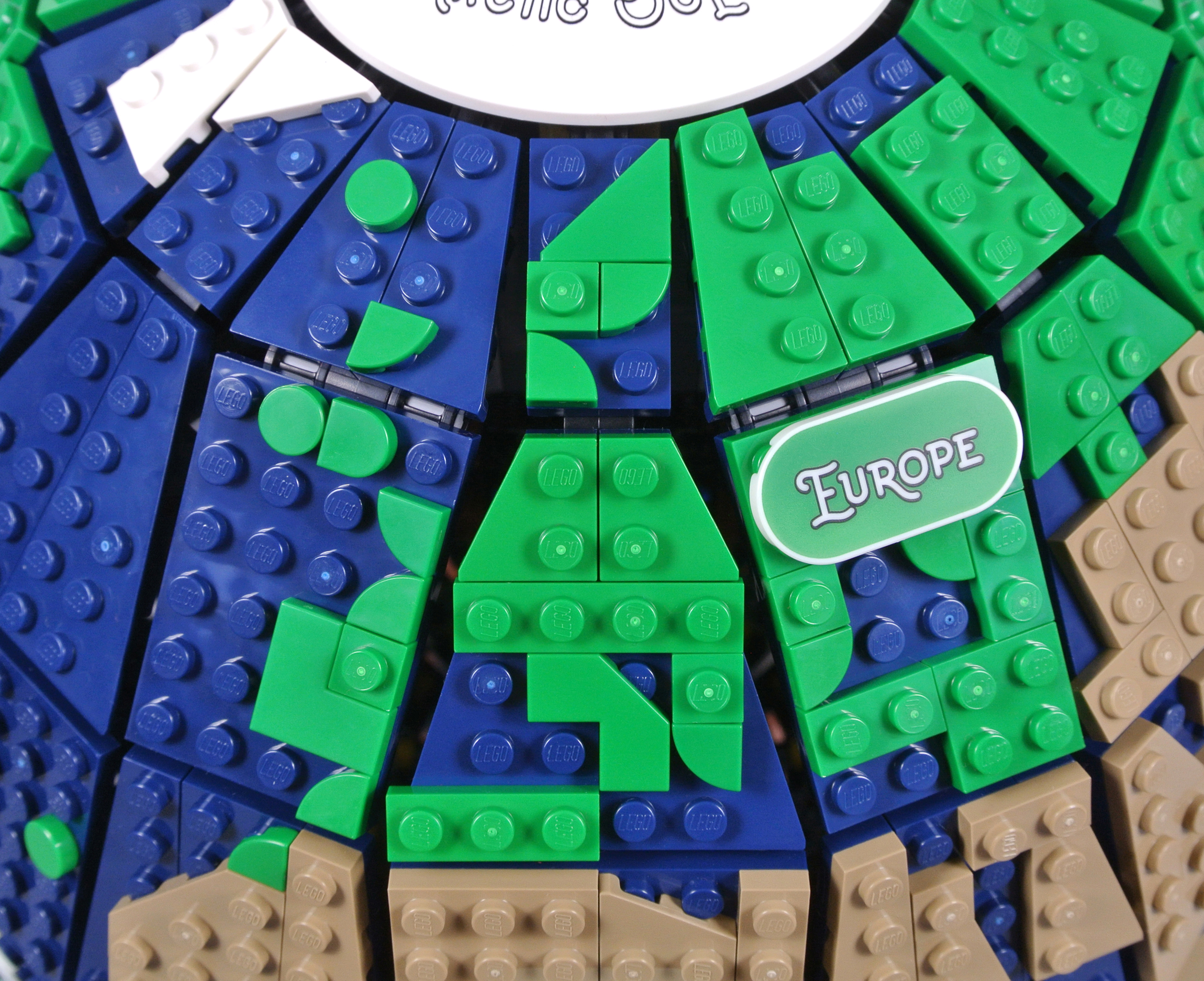
While the reaction to 21332 The Globe has been mainly positive, the inaccurate design of Europe has provoked concerns.
The original project achieved greater accuracy in some regards, although Europe was enlarged and North Africa compromised to accommodate further detail.
I have therefore attempted some basic changes to find whether Europe can be improved, without altering its size or neighbouring continents.
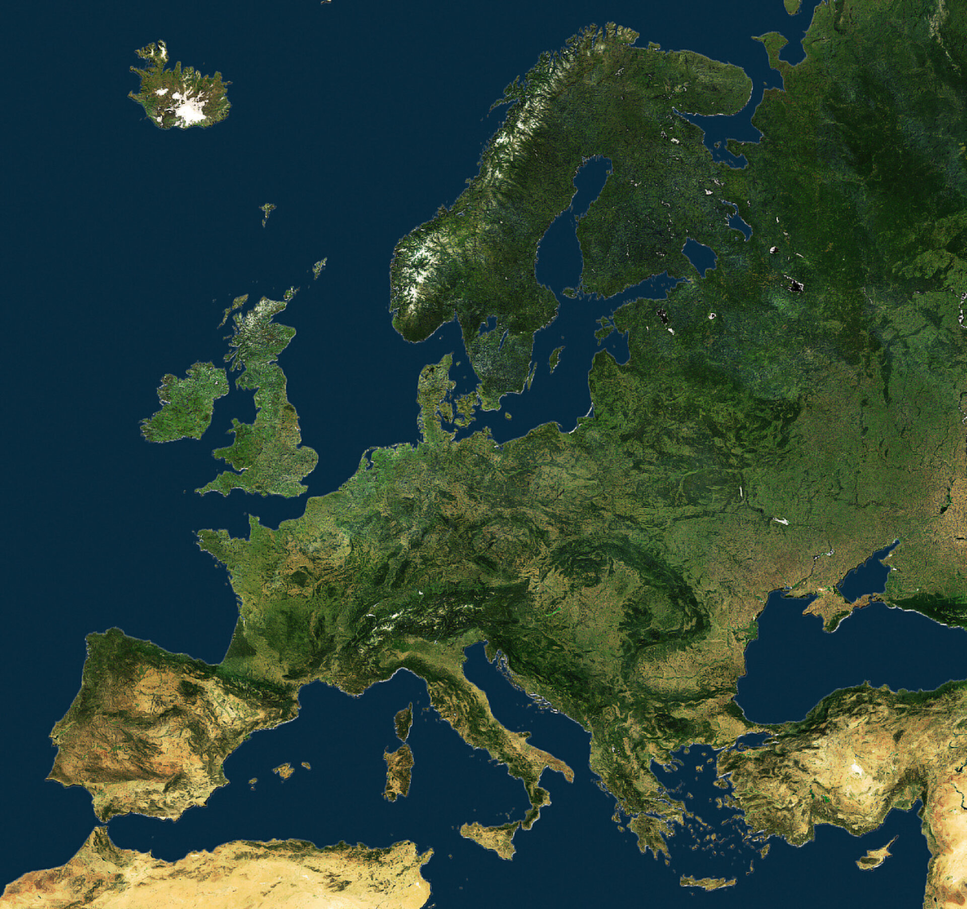
Earth from Space: United Europe - ESA
Comparing the original map with 21332 The Globe reveals the documented inaccuracies, since Brittany is completely missing from France and the Italian and Balkan peninsulas both appear truncated. I think Iberia also looks awkward, as though part of Portugal has been submerged! Additionally, omitting Brittany creates a gap between the British Isles and Continental Europe.
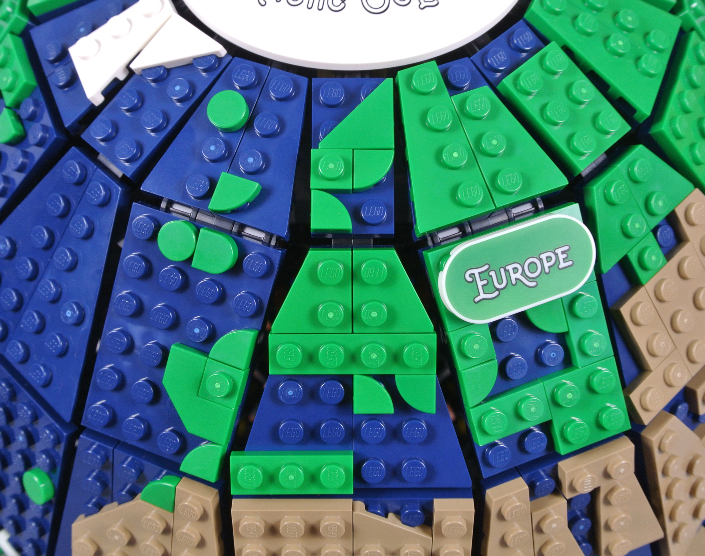
Numerous spare pieces are included and those alone are sufficient for some adjustments. This arrangement, which extends the Italian and Balkan peninsulas, involves only another 1x1 plate and 1x1 quarter circle tile. Another of those tiles forms Brittany on the Western coast of France, also narrowing the English Channel. The inevitable gap between that 1x1 quarter circle tile and the neighbouring 2x2 wedge plate is apparent though.
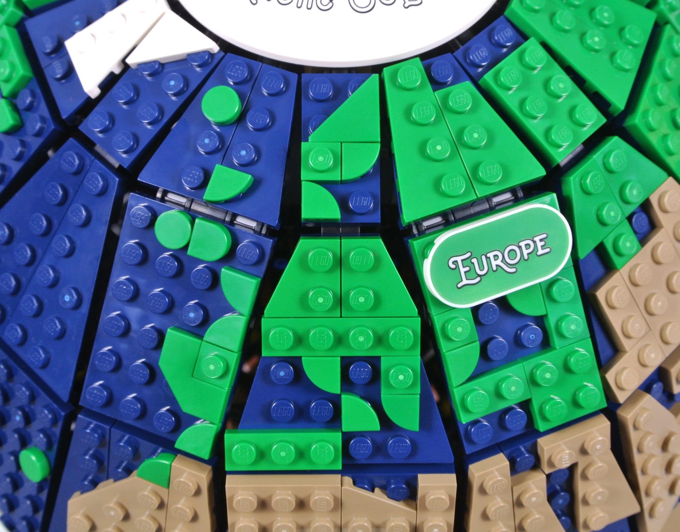
However, the shape around Spain and Portugal appears inaccurate. I therefore replaced the 2x2 angled corner tile with a standard a 2x2 corner tile. The latter element is only found in two recent sets in the appropriate colour, unfortunately, but I think the resulting design seems reasonable. Furthermore, the angled corner tile is then available to portray Italy.

None of these designs are perfect and I think achieving complete realism would probably be impossible, with the aforementioned gaps in the sphere. Nevertheless, I do think extending the Italian and Balkan peninsulas enhances the model, even when simply using spare parts from the set.
Which design is your favourite and do have you have any further suggestions for updates? Let us know in the comments.
133 likes
85 comments on this article
I’m glad LEGO didn’t enlarge Europe/the Northern Hemisphere at the expense of Africa and other southern continents. It shows a commitment to realism and opposition to eurocentrism. That said, some of these alterations do look better, so well done!
They clearly should have made the entire globe smooth and given us stickers....
I applaud your efforts on Europe, even the original design was only ok but Lego just seem to have got it wrong. Its a shame as the concept is wonderful but the finished product is some what ugly. I really wanted to buy this set but whats the point if I don't even recognise my own country.
I'm sure all the people that loudly complained about it are just /dying/ to show us their suggestions.
Should just be a big sticker haha
the first one, with just 3 more pieces looks so much better... the scaling might be more of for some details of Europe now, but it feels more right and not like something is missing :>
I will be buying the globe, and I will be modding it my liking.
To me, that's the joy of Lego -- the building and the modding.
THe first change looks the best.
I'd also be tempted to move the quarter circle at tip of N Africa 1 stud West as the Straight of Gibraltar is too far East, I think. Then I could rotate both pieces used for the Iberian Peninsula 90deg counter-clockwise which would overcome the clipped Portugal and provide a better shape for southern Spain.
@empire0 said:
"They clearly should have made the entire globe smooth and given us stickers...."
I know this is a joke but I'm still angry about it >:|
Europe looks fine on the globe on my desk (about the size of a baseball and the base is a pencil sharpener). That is because it's printed. With LEGO, intricate things like globes/maps can be difficult as you have to work with existing parts.
Unless LEGO does a globe in Modulex, I don't see how it can be improved without changing the scale completely.
I wonder if its possible like lego art map... to do same with the globe?
I'm interested in a challenge.
Recreating the Mario Odyssey world map with this set.
I think the Lego Globe is superb bearing in mind it's a representation of a globe, and not of individual continents. Changing the odd stud here and there is obviously very easily possible, but barely noticeable from normal viewing distances, so is neither here nor there!
So often there are complaints that a real one is more accurate and cheaper (Typewriter, NES, Trainer, etc) but that really is missing the point of Lego!
Typical of a UK site to go and try to improve Europe :D
It was funny to read Brittany as a part of France. You see: Brittany but not in Britain.
It turned out, you call Bretagne this way.:)
@NatureBricks: If "literally anything" is better, then just leave Europe off.
I think they did an overall good job with the scale they had, and given the user base of the site, it's unsurprising so many are fixated on the errors in Europe. But every complicated coastline, especially on a joint between segments, is equally jacked. Southeast Asia/Indonesia, the Red Sea/Persian gulf, the Caribbean, the Maritimes provinces of Canada, all look pretty far from their actual form.
I didn't know that people hated that part of the build since I didn't read the comments sections of the articles about this set but I came up with a joke about people on here just removing everything but the Europe part. It turns out that the reverse is the case.
As for me, I'd take out anything other than America as a proud cheeseburger pickup truck gun citizen. Maybe I'd leave in Japan as well, being the weeb that I am. Or I'd only remove Italy, it's not like I wouldn't be alive without them or anything.
As well as Capn’s modifications, I’d be tempted to replace the green 1 x 3 across the north of Algeria and Tunisia with a 1 x 2 to help restore the gap between Italy and North Africa.
Get rid of the that quarter round tile and the one by 3 green tile both right above Africa and that'll help.
If you don’t like it then just rotate it around to North/South America. ;) hehe
Like someone mentioned before, maybe just have printed or stickered pieces lol
Sorry, but if you showed me any of those without context, I wouldn’t recognise any of them as being a representation of Europe. The set is a fail for me for this reason alone.
They should have selected another set from the batch if they couldn’t accurately represent Europe. How it got through all stages of product review to release is a mystery to me.
@empire0 said:
"They clearly should have made the entire globe smooth and given us stickers...."
how can you even joke about that!?! ;)
with how people are acting, the rest of the continents could have been wiped off the face of the globe and no one would notice! (or care)
I think it's already generous as it is, since Europe is really just a subcontinent of Asia
*ducks to avoid tomatoes*
Scandinavia remains a mess. Replace the 1x1 tile at the base of Norway with a quarter circle oriented like the base of Sweden and rotate the quarter-circle representing Denmark to an upper-left quandrant instead of an upper-right one, and things might be better. Also, a solution to the problem of the Iberian peninsula might be a 1x2 representing the eastern side of the peninsula with another quarter-circle (oriented as a lower-right quadrant) to represent southeast Spain; this would open up the straits of Gibraltar a little better. Also, I'd flip Scotland into an upper-left quadrant, and the "foot" of Italy into a lower-right (or perhaps upper-left?) one. I prefer your first solution to the Mediterranean Sea; the second one really distorts the shape of Italy too much for my taste. You clearly show that only minor fiddling can really improve the shape of Europe without compromising the other land masses, though, and that's wonderful. Thank you!
Fiddling with the tiny details is most of the fun (for me at least) with any Lego set; why should doing that with this model be any different? I'm sorry people seem more inclined to complain (or counter-complain) than to try their own hands at continent-building.
You Europeans are funny. I don't hear anyone in the US complaining that Cape Cod is missing from Massachusetts, there are no great lakes, or about the lack of San Francisco Bay or Puget Sound. (We're used to Florida having issues though, so that's to be expected) Where are the Canadians complaining about the Pacific islands or maritime provinces? Poor Bermuda isn't even on the globe at all!
It's Lego, for pete's sake! The resolution is only so precise. Get over it or you'll never be happy.
What's up with all the European bashing? I think the main point is that many countries can't be recognized that should be large enough to be distinguished (I'm not complaining that my homeland NL is invisible). I don't think any American or Canadian had trouble finding their country even if it's not perfectly accurate.
Another option could have been 3 printed tiles: one 2x2 representing the UK and Ireland, the second also a 2x2 representing the Italian and Balkan peninsulas and the third tile would be 1x2 and would show Denmark and southern Sweden. All tiles would be dark blue with the land masses in green. Of course doing something like this would give a good representation of these countries but then people from other places around the world would cry of favouritism; then you would need a whole bunch more for the Caribbean and most of the pacific isles. In the end, one has to accept that this is Lego, it is meant to show what is actually possible to build out of Lego and not to present an accurate representation of the earth. Or ever simpler, just tell people that this is a globe dating back to 1500ish - this is roughly how much was known of the planet at that time (not true but just stick to it!).
@GIJM said:
"I think it's already generous as it is, since Europe is really just a subcontinent of Asia
*ducks to avoid tomatoes*"
I'll just take the globe, build Europe four times the current size and use a 1x1 round tile for each of the other continents :-p
My question is can you “flip” the globe over so that the Australian continent is on top where it should be?
Can Europe be improved in the 21332 The Globe? It is asking a lot of a Lego set isn’t it? Surely this is a job for the EU.
@Alatariel said:
"What's up with all the European bashing? I think the main point is that many countries can't be recognized that should be large enough to be distinguished (I'm not complaining that my homeland NL is invisible). I don't think any American or Canadian had trouble finding their country even if it's not perfectly accurate. "
To be fair, the United States and Canada are substantially larger in size than essentially every European country
@Alatariel said:
"What's up with all the European bashing? I think the main point is that many countries can't be recognized that should be large enough to be distinguished (I'm not complaining that my homeland NL is invisible). I don't think any American or Canadian had trouble finding their country even if it's not perfectly accurate. "
America and Canada are bigger than most European countries. I didn’t mean to Europe-bash if that’s what it seemed like I was doing, I was just trying to make a bunch of goofy edgy jokes.
I think it could be pretty awesome if Lego produced special tiles in the shape of certain coutries. Or certain regions.
@lippidp said:
"Should just be a big sticker haha"
I think the NA version would be two stickers: "USA" and "Not USA".... ;-)
(sorry - couldn't resist!)
All they needed was 7 more parts.
(BUEP = Big Ugly Europe Piece)
Personally I think the only thing missing from this set is a motor!
@empire0 said:
"They clearly should have made the entire globe smooth and given us stickers...."
You made my day!
Personally, I don't really think the "improvements" suggested here are that effective. The amount of detail that gets added feels excessive compared to the rest of the continents, and turns a low-detail but clean-looking representation of Europe into a muddled mess. Recognizable features like bodies of water end up feeling chopped up and segmented by the landmasses when you reduce the things like the clearance between Italy and Africa to the point where it's even narrower than the "gaps" in the faces of the globe itself.
The only reason the Iberian Peninsula used a tile is that the shape they wanted was only available as a tile. I don’t see why you used a 2x2 corner tile around a 1x1 plate when you could have just used a 2x2 plate. The only instances I can see where they used a tile or tile-like surface where a matching plate was available is 1x1 round. But a 1x1 round tile looks wider than a 1x1 round plate because the wide part is bulkier, and you’re not distracted by the narrower stud.
Personally, I’m in favor the idea of rotating the existing Iberian Peninsula 90° so the missing corner is in the SE instead of the SW, and probably rotating the tile representing Point Cires 90° clockwise as well.
@TheOtherMike:
Even in Newton’s Cannon, only England (or at least the part where London was located) gets wiped from the face of the Earth.
@joshhaslego:
Did they fill in the Western Hemisphere? I haven’t seen much proof that it exists.
@PDelahanty:
I mentioned the lack of Great Lakes. I noted that, along with Florida, Alaska, and Hawaii, it’s one of four US states that can be recognized solely by the shape of its coastline. Of those four, it’s the only one that‘s missing.
@Alatariel:
Most of the complaints about the final set have focused solely on the depiction of Western Europe, and many of the people who posted them suggested they were skipping the set because of it. A lot of island nations are too small to even show up, and landlocked nations like Mongolia, Zambia, and Paraguay aren’t identifiable due to the lack of political borders. Yes, the US and Canada are easy to spot, but we’re two of the four largest nations by area, and the only two of those that span an entire continent.
I think the worst part was how many people suggested the original submission was better, even though Europe ate an entire strip off Northern Africa and became grossly inflated in size as a result (something that globes are supposed to avoid).
@Lyichir said:
"Personally, I don't really think the "improvements" suggested here are that effective. The amount of detail that gets added feels excessive compared to the rest of the continents, and turns a low-detail but clean-looking representation of Europe into a muddled mess. Recognizable features like bodies of water end up feeling chopped up and segmented by the landmasses when you reduce the things like the clearance between Italy and Africa to the point where it's even narrower than the "gaps" in the faces of the globe itself."
I understand your reasoning, but disagree. For example, Florida and Italy are each depicted by a single 1x1 quarter circle tile, even though Italy is almost twice the size of Florida. Also, I think certain areas of the Mediterranean Sea are sufficiently narrow that representing them with less than a single stud is sensible.
Fundamentally, Europe is simply more geographically complex than many other areas of the world. Omitting particular details is therefore inevitable, but I think we would expect Europe to appear a little more muddled on the model because the continent is relatively complex in reality!
I think there needs to be a point where people go, “Ok, this is a Lego representation of a real item. It’s not going to be 100% accurate.”
The Typewriter doesn’t type on a page. The Adidas’ can’t be worn. And that’s fine.
It's still upside down.
I mean, it's better than the disaster LEGO made.
I still think it could be improved by removing the green quarter round tile which would be Ceuta, and the 1x3 green plate that extend Argel and Tunisia to the upper segment of the globe.
I'm getting this but I think I'll be performing some heavy mods on it...starting with making Europe bigger and either putting Africa one stud lower...or just reduce its overall size.
Yeah, I know it won't be geographically accurate. But I'll just be brutally honest about it: I'm in Europe and that's kinda the only continent I care if it's well represented on the globe or not.
Wow the Iberian Peninsula really is very square in real life, isnt it
@Ridgeheart:
This may come as a surprise to you, but many of the Europeans who bash Americans for not having an in-depth understanding of European geography think the US is as small as their own nation, just because they look the same size on one-page paper maps. Someone I knew in college had family from Germany visit him in Michigan, and they thought the Grand Canyon would make a nice day trip. Just the official US spans six time zones, without counting territories, protectorates, and the like. We have individual national parks bigger than many European nations. Heck, we probably have some roads that are wider than a couple European nations.
The inability to represent a realistic map on a globe , is conclusive proof that the Earth is flat ??
@GIJM said:
"I think it's already generous as it is, since Europe is really just a subcontinent of Asia
*ducks to avoid tomatoes*"
No Asia is just a subcontinent of Europe ;)
The only problem is that it isn’t flat :) :) :)
But everybody thanks for the good laughs. I needed it.
It is slightly better with your changes, but still very inaccurate and not worth buying in my opinion (at least for a European...)
It probably won't satisfy anyone who is disgruntled about this, but Europe is the only continent to get its own version of 31203 World Map.
https://www.lego.com/cdn/cs/set/assets/bltb18689cf58422477/inspiration_build_europe_31203.pdf
Lego clearly cares about its home continent, and this does what can be done at a much larger scale. There's a Denmark-only version, too.
Just mod Europe to look like the old pirate map.
Looking at the ESA map, shouldn't the whole Iberian peninsula move one stud to the left? The square shape does seem to be the most accurate. And then move the quarter-tile for North-France one up and one left (making Brittany), and put a 1x2 plate vertically to the right of it. I like the two quarter tiles for Italy better.
Yeah moving Iberia a stud to the left would also make the British Isles seem less out of place I think.
Honestly.. save yourself some money from buying Lego 'real-life' models and just buy the real one if needed. Yes a Typewriter that won't type, a Piano that pretends to make a sound, a Shoe that is not wearable, a Globe that is not precise. This is all very well understood and it's okay, due to the implementation of the design using bricks.
Funny enough, there are people who buy these things knowing the limitations. Like it's frequently mentioned, there will always be a market for anything that Lego produces, isn't it?
@empire0 said:
"They clearly should have made the entire globe smooth and given us stickers...."
We'll see you in the Hague
I never expected this set would cause so much controversy (I imagined few people would be interested in it at all, similar to the world map).
I for one think the designer did a pretty good job coming up with a generally recongizable product, given the limitations, it's not possible to have something that's 100% geographically accurate at the scale of a lego stud, and if you don't like it, tweak it yourself as above.
Finally, Europe came out much better than South East Asia, for example....
Objectively, the only way to improve it would be increase the actual globe size, thus enabling more detail, make it stickers, or make some sort of entirely new piece. The latter two aren’t going to happen, and making the globe bigger wouldn’t be advisable.
@Alatariel said:
"What's up with all the European bashing? I think the main point is that many countries can't be recognized that should be large enough to be distinguished (I'm not complaining that my homeland NL is invisible). I don't think any American or Canadian had trouble finding their country even if it's not perfectly accurate. "
It's because eastern Canada is bigger than the entirety of Europe. Yet if you divide by province (which are somewhat closer in scale to some of the bigger European countries), you still can't recognize them well. Quebec for example, with the Maritimes, have very peculiar shapes, all absent from the globe.
So while I don't think there's a need for european bashing, for sure the european outrage is hilarious. It's a great set, at a very nice scale, but it just doesn't show fine details. Buuuut, it's Lego and customizable, who would have thought?
Great article CapnRex, I'll take a look at your ideas once I get the set!
@Mr__Thrawn, @Trigger_, @PurpleDave, @Phoenixio
Thanks guys for explaining to me that Canada and the US are bigger than any country in Europe, I had no idea (oh wait, I have actually lived in both those countries).
Kidding aside, the key part of what I wrote was "should be large enough to be distinguished". It's valid to suggest there's room for improvement for some countries' representation and this also applies to some non-European countries. Personally, I look forward to seeing what people come up with.
I don’t care about being able to distinguish individual European countries. That isn’t the issue. Europe as a continent is unrecognisable. That is the issue.
And if they couldn’t manage that then the set shouldn’t have proceeded.
I'd like to see a different version of the globe with glow-in-the-dark pieces used for heavily-populated areas. Then, on that or a different model, a mix of earth blue and bright blue for deep and shallow water, earth green and dark green for tropical and temperate forests on land, sand yellow and brick yellow for deserts, and white for glacial areas.
I know that's asking for a lot of detail... but even just turning out the lights and seeing the night-time view with the glowing bricks would be awesome.
@Ridgeheart:
Is it weirder to say it, or that I can prove it?
https://top-10-list.org/2010/04/24/top-ten-widest-roads/
Item 2 mentions a section of freeway that’s 26 contiguous lanes wide. Item 8 is a divided highway that includes 27 lanes at one point. But what I was really thinking of was stuff like Item 9, where the famous Route 66 is noted to reach half a mile in width (probably where opposing lanes of traffic diverge around something, like a river parting around an island. Measured NW to SE, Vatican City looks like it would just fit.
@Alatariel:
Isn’t Russia still in Europe, or did you vote them out?
@TeraMedia:
That would require a surprisingly large increase in the level of detail, which would probably look terrible. At some point, the only way to make it look good enough to satisfy people is to create a new mold and decorate it, at which point the “just buy a globe” people kinda start to make sense.
For colors, I’m used to seeing two types of Earth globes. One is the political type, where individual nations are depicted in one of four different colors (because that’s the lowest number that allows any two neighboring nations to be different colors), and the other is the “satellite view” globe, but those are usually four colors (blue, green, tan, and white), with no variation in shades except where two of the four colors are blended together. Maybe if you have a significantly larger budget there are globes that expand the number of colors to better match reality, but I haven’t really spent a lot of time shopping for globes.
@gunther_schnitzel said:
"I don’t care about being able to distinguish individual European countries. That isn’t the issue. Europe as a continent is unrecognisable. That is the issue.
And if they couldn’t manage that then the set shouldn’t have proceeded."
And yet you could still locate it just fine on the lego globe if asked to.
@PurpleDave said:
@Alatariel :
Isn’t Russia still in Europe, or did you vote them out?
Since when does anyone get to vote whether another country belongs to a continent or not?
@monkyby87 said:
" @gunther_schnitzel said:
"I don’t care about being able to distinguish individual European countries. That isn’t the issue. Europe as a continent is unrecognisable. That is the issue.
And if they couldn’t manage that then the set shouldn’t have proceeded."
And yet you could still locate it just fine on the lego globe if asked to. "
Only because it is right above Africa on the globe, and of course it has a sticker / printed piece with ‘Europe’ to avoid ambiguity.
@Ridgeheart said:
" @PurpleDave said:
" @Ridgeheart:
Is it weirder to say it, or that I can prove it?"
It's mostly weird that you think this is something worth boasting about, but you do you, babe."
lol relax
@PurpleDave said:
"We have individual national parks bigger than many European nations."
That’s true. Wrangell National Park, for example, is larger than Belgium. But then again, the UK - itself a small country - has individual national parks that are bigger than many European nations, so that’s not saying much.
I agree that the modifications help, and the ease of changing a design to suit is one of the best things about Lego.
However, I'm afraid that neither version of this set reaches the level of accuracy Lego has already reached with part 61287pb002. https://www.bricklink.com/catalogItemIn.asp?P=61287pb002
@BrickTeller said:
"I agree that the modifications help, and the ease of changing a design to suit is one of the best things about Lego.
However, I'm afraid that neither version of this set reaches the level of accuracy Lego has already reached with part 61287pb002. https://www.bricklink.com/catalogItemIn.asp?P=61287pb002"
Wrong— the ocean isn’t dark tan and not every area of the earth is reddish brown smh my head.
I like the first change with Italy being two quarter tiles best. The second proposal not so much.
Another possibilty could be changing the colours:
Big green plate as baseplate and then small dark blue tiles and plates on top. Maybe one could achieve a better shaping of the coastline with this. It will look weird if you look up close because of the water being on top of the land. But it could work from further away.
There's a "rule" in journalism that when an article asks a yes or no question, the answer is always "no." I was pleasantly surprised that some improvement was made. I like the second image the best, like many others.
In 50 years, if rising sea levels have ravaged coasts all around the world, we may look at this globe and realize LEGO was simply ahead of the times.
@Wrecknbuild said:
"I'll just take the globe, build Europe four times the current size and use a 1x1 round tile for each of the other continents :-p"
Why not just use the labels to represent the other continents?
@tkatt said:
"In 50 years, if rising sea levels have ravaged coasts all around the world, we may look at this globe and realize LEGO was simply ahead of the times."
At the very least, we will all have to be redesigning the maps frantically, grateful that at least one globe we own is capable of being redesigned! :-P
I like the last image shown. I think that is a good update, or as good as it could be.
@Alatariel:
Seems to be happening a lot in the comments on these Globe articles.
@Zander:
Gates of the Arctic (second largest) is also bigger than Belgium, but not by much. It’s also one of the least visited national parks, which is kinda what they intended. Unspoiled wilderness and all that. I’ve been to Yellowstone off peak tourist season and seen someone dip fingers in the runoff from Grand Prismatic (stupid, and illegal), and then read about someone walking right out to Old Faithful the week after we visited (extremely stupid, and earned them a fine and a ban from the park), so I definitely get it. Besides, I did the math on it, and if you add up all the land that’s managed by the National Park Service, it’s a bit bigger than the UK. Not all of that land needs to cater to tourists.
@BrickTeller:
That’s missing the entire Western Hemisphere! And Antarctica! And there’s a hole at the South Pole where people can get their head stuck!
@tkatt said:
"In 50 years, if rising sea levels have ravaged coasts all around the world, we may look at this globe and realize LEGO was simply ahead of the times."
By 50 years time I'll be well past caring!
Any suggestions? Yes!! Why would you need a globe just to see the continents. Is it really usefull? Turn this thing into a death star, or why not a black and lava planet with a light glowing from the inside.
We're the men, and here's the map.
Map men, map men, map map map men men.
;-)
@Alatariel said:
" @Mr__Thrawn, @Trigger_, @PurpleDave, @Phoenixio
Thanks guys for explaining to me that Canada and the US are bigger than any country in Europe, I had no idea (oh wait, I have actually lived in both those countries).
Kidding aside, the key part of what I wrote was "should be large enough to be distinguished". It's valid to suggest there's room for improvement for some countries' representation and this also applies to some non-European countries. Personally, I look forward to seeing what people come up with. "
You are most welcome, it wasn't obvious that you knew that some countries are smaller, since you arbitrarily decided that Europe had to be big enough but not any other place. Poor Oceania people that got simili islands if we can even see them, or those of western Asia in that blob of undefined land. But it's obviously because of selfish big bad countries like Canada and the USA who have this 4k resolution of their land...
Seriously, it's a Lego globe of a given scale, of course there are going to be resolution issues. It's still a gorgeous globe wich obviously shows Earth.
I will be making my own adjustments when I buy a copy of this.
Starting with some of the larger blue triangle plates, to give me more studs, allowing me to move the UK closer to France, Belgium, The Netherlands and Denmark.
Some reshaping of Portugal and Italy will also happen.
There will be other parts of the world which seem wrong to me, so I will also reshape them.
Does anyone think that Turkey looks too squared off and that the Black Sea is too large? western eurocentrism
Personally, Europe look like a mess on this LEGO Globe. All the other countries are easy to recognize. Just Europe is a mess...
My personal opinion: Make the set bigger so that Europe gets a chance to be better made.